We recently published the paper A Framework for Reducing Place Based Equity discussing how cities should take and evaluate actions spatially, giving attention to the previous disproportionate impact over time of underinvestment and lack of access. We saw one example of this type of official action last summer when many cities experienced the effect of extreme heat, causing excess hospitalizations and deaths that disproportionately affected certain communities.
Dealing with extreme heat presents serious challenges for cities—both their governments and their residents. Cities have overbuilt their environments, creating urban heat islands with a combination of asphalt, concrete buildings without landscaping and shade, and a lack of vegetation and trees, trapping heat and increasing temperatures.
The elimination of tree canopies and vegetation, as well as permeable land, exacerbates the urban heat island effect. Extreme heat has consequences that unequally affect under-resourced neighborhoods that were historically redlined. These areas already have high rates of various chronic illness such as asthma, COPD, and kidney and heart disease. Extreme heat exacerbates pollution and smoke, plus creates additional stressors on bodies, especially for those with existing chronic illness, children, and seniors. Officials are now also looking at connections between extreme heat and infant mortality and the correlations between complicated pregnancies and extreme heat.
Dealing effectively deal with heat and heat-related illnesses requires several mechanisms at the city level, three of which are the following: 1) the ability to see the complexity and effect of the problems created by extreme heat through a public health, climate ,and equity lens, and 2) identify solutions through a data driven spatial lens, and 3) a leader whose authority applies across agencies with a cross-sectoral approach to reducing silos improving accountability, within a structure empowered by the executive office that gives the leader power to influence decisions on spending for climate infrastructure and services.
In short, preparations for extreme heat events and the inevitable climate and public health emergencies require a well-coordinated structure with a mandated leader to guide and envision the pathways needed to accelerate the solutions. And in January 2021 residents of Los Angeles gained such a leader in Marta Segura, MPH, when she became the founding Director of the Climate Emergency Mobilization Office (CEMO) for the city of Los Angeles; in June 2022 she was designated the city’s first US chief heat officer (CHO), joining CHOs in Miami and Phoenix. Although her position sits inside the Department of Public Works, her mandate reaches beyond her department and stretches across several agencies responsible for heat mitigation, with allocated funds for infrastructure and services to reduce the impact of heat and its cascading effects on clean air and health.
Place-based analysis is a fundamental part of responding to heat emergencies. As we wrote in Collaborative Cities: Mapping Solutions to Wicked Problems, “What is rooted in systems is experienced in place, which is why place-based thinking is so important to the design and delivery of services. It is also why geocoded data can serve as a powerful tool in the collaborative toolbox.”
The federal government's Justice40 initiative created incentive and momentum for cities to focus attention on the historically most challenged communities. But Justice40 is just a start, as a more finite analysis of geographic information systems (GIS) oriented conditions and solutions is necessary. Cities such as LA utilize advanced spatial equity analytics to look at smaller areas inside J40 categories, allowing planners to draw insights from layers of data—the demographics of the community and its health characteristics as well as physical infrastructure such as green spaces, bus shelters, and more. The federal government’s National Integrated Heat Health Information System provides maps of heat and health that facilitate insights between Justice40 and spatially organized heat and health data.
“We need climate, equity and health data and metrics to create a dashboard that actually shows us the needed, and occurring, climate infrastructure investments for all,” said Segura “but especially the historically disinvested communities.” LA applies its Equity Index and Heat Risk Mapping to measure their climate infrastructure investments and demonstrate the health disparities as a measure of risk. One of her main goals is a reduction in deaths and hospitalizations correlated with extreme heat.
In addition, this layered data of health, heat risk, rising temperatures, and the built environment serves as a foundation for cross agency support and collaboration. In Los Angeles there are many departments and city officials with responsibilities for sustainability, environmental justice and public works, forming a multi-pronged approach that incorporates meaningful community engagements. The mapped heat risks and resources and understanding of what heat mitigations are required such as trees, bus shelters, cooling centers, resilience hubs, and hydration stations, create opportunities for Segura to visualize the forest for the trees (pun intended), and create systemic changes that can then in turn can be scaled.
The chief heat officer and her team have the key responsibility for engaging with frontline, pollution burdened, high-heat-risk communities. Being able to have direct connections with community-based organizations and bring them into conversations with city agencies helps officials identify local hazards and opportunities for mitigation. In addition, CEMO works with the Emergency Management Department and the Fire Department to design the Local Hazard Mitigation Plan and emergency operations services and plan responses for communities mapped as the hottest and least well served, which in turn predicts the location of more frequent heat-induced emergency calls.
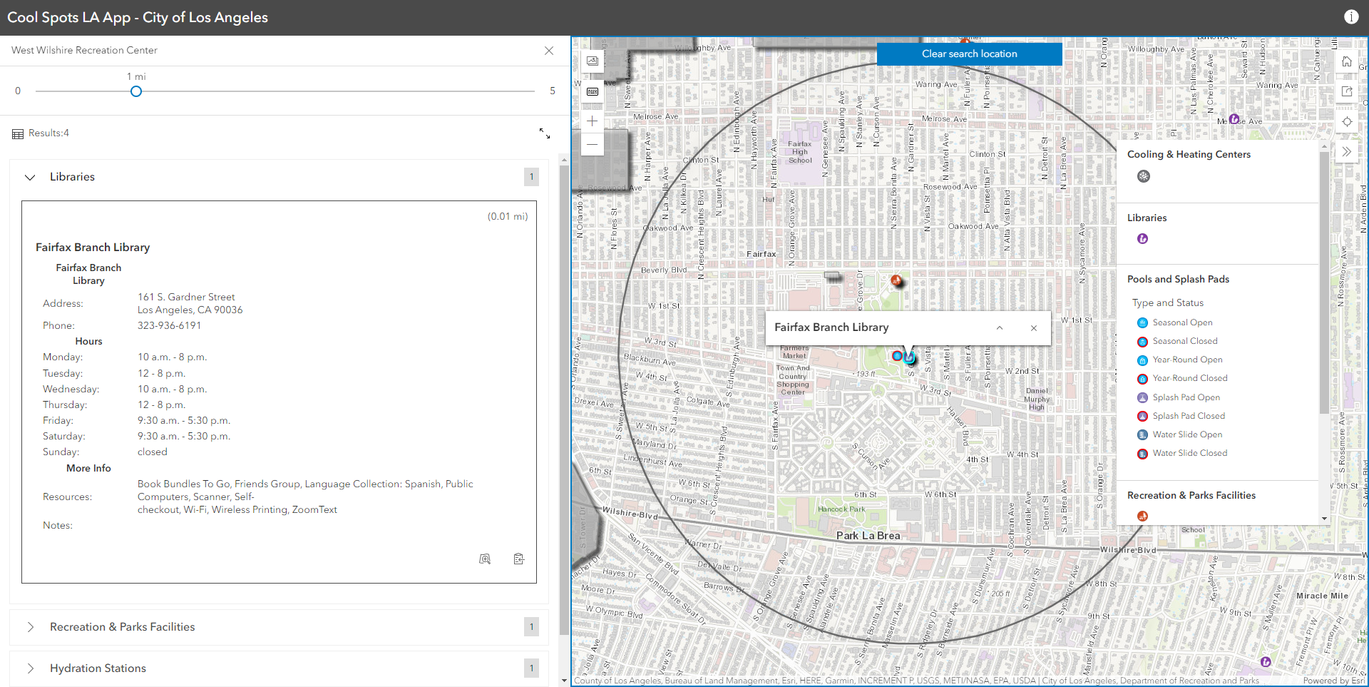
Cross agency engagement helped Segura create the Cool Spots LA Map and App. “Through this web-based ArcGIS map, the city was able to map all of its cooling centers, hosted at Public Libraries, Recreation and Parks Centers, Senior Centers, hydration stations, and bus shelters,” Segura said, “This process facilitated access not just for our communities, but also for our city’s 311 system, so that dispatchers have accurate and accessible information."
Heat mitigation strategies will have the greatest potential in the underserved and historically redlined areas where the impacts of any disaster are the greatest. In future articles we will review other solutions such as equitable tree plantings, including how officials choose the location and type of trees by using layered data, and surface mitigations such as creating lighter streets and roofs, installing solar panels and window shadings, and establishing permeable surfaces. We will also discuss preemptive measures such as reducing road congestion in order to reduce heat-trapping pollution.
Extreme heat can produce a complex web of problems and thus requires a broad set of responses. And to be effective across this breadth necessitates a leader with vision and a mandate to work across departments in a way that is informed by data and communities, with the mission to create aligned planning and mitigation through a place-based strategy. LA shows us the path required to accelerate solutions to current climate issues while also establishing a trajectory toward a healthy, thriving community for all.
Want to learn more? Listen to Marta Segura on the accompanying Data-Smart City Pod, hosted by Professor Steve Goldsmith.
About the Author
Stephen Goldsmith
Stephen Goldsmith is the Derek Bok Professor of the Practice of Urban Policy at the Harvard Kennedy School and the director of Data-Smart City Solutions at the Bloomberg Center for Cities at Harvard University. He previously served as the mayor of Indianapolis and deputy major of New York City.
Betsy Gardner is the editor of Data-Smart City Solutions and the producer of the Data-Smart City Pod. Prior to this, Betsy worked in a variety of roles in higher education, focusing on deconstructing racial and gender inequality through research, writing, and facilitation. She also researched government spending and transparency at the Lincoln Institute of Land Policy. Betsy holds a master’s degree in Urban and Regional Policy from Northeastern University, a bachelor’s degree in Art History from Boston University, and a graduate certificate in Digital Storytelling from the Harvard Extension School.