According to the US Geological Survey, “sea-level rise is resulting in chronic erosion on many Hawaiian beaches. On the island of Kaua’i, approximately 73% of sandy shorelines are currently retreating inland.” While a healthy beach could temporarily gain and lose sand without serious consequences, the sea level rise in Kaua‘i is far above normal, and officials knew they needed to take immediate, data-informed steps to embed resiliency into their development program. Historic data, such as the data used in the FEMA Flood Program, are most frequently used to achieve resiliency goals but they fail to consider future impacts of sea level rise. Modeled projections of hazards have existed for years but policy tools have been mostly unsuccessful in mandating mitigative actions, often being relegated to providing development recommendations rather than requirements. While historic data is helpful for long-range planning efforts, Kaua’i officials wanted to ensure that their regulatory policies took advantage of the latest and greatest scientific data and looked to the future.
With much of the island’s small population and critical infrastructure situated near the coast, rising sea levels threaten Kauai’s communities with chronic flooding and displacement. In an effort to better prepare Kauai for the hazards of the 21st century and beyond, the county established the Sea Level Rise Constraint District (SLRCD) to help mitigate the effects of sea level rise hazards including passive flooding and high wave runup. At the heart of this program is the Kauaʻi Sea Level Rise Constraint District Viewer, an innovative data visualization tool that was created by the County’s Planning Department, building from data generated by the Climate Resilience Collaborative (CRC) at the University of Hawaii.
According to Alan Clinton, the county’s administrative planning officer, the county had previously adopted an incredibly progressive Shoreline Setback Ordinance to limit development along Kauai’s dynamic coastline. The Shoreline Setback Ordinance (adopted in 2008) relies on a formulaic place-based approach taking advantage of historic shoreline erosion data to more appropriately site structures away from the volatile shoreline. While this was an important step, once newly published hazard data had been released by the CRC which indicated more severe sea level rise associated flooding risks, “we ran into a bit of a snag when we were trying to find new ways to incorporate data about future conditions into our regulatory framework,” said Clinton. While searching for the ideal policy mechanism to incorporate the data, it was also becoming untenable to utilize paper maps. “With datasets of this size there is no practical way it would do justice to the data — even if we wanted to show it on paper it would require hundreds if not thousands of sheets of paper,” said Clinton “out of necessity we were required to find a dynamic mapping tool that would allow people to hone in on their area of interest.”
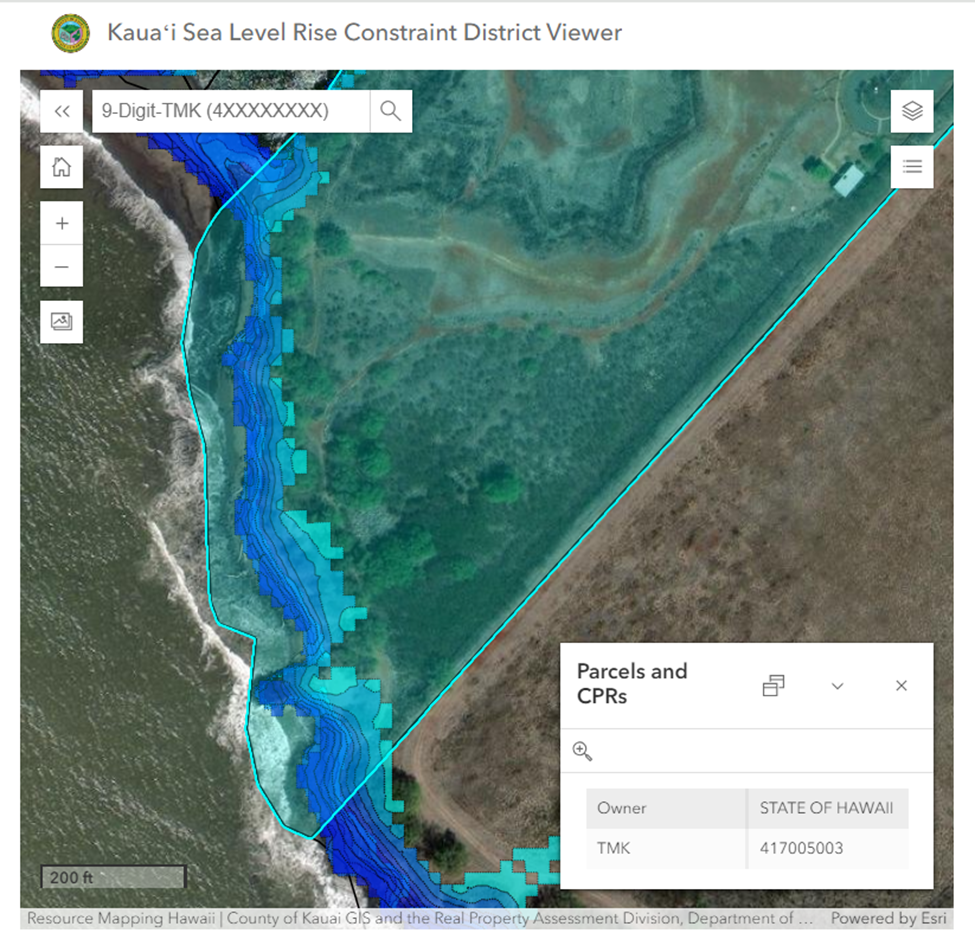
The Planning Department turned to ArcGIS InstantApps to develop a Viewer, that could display the future hazard data for passive flooding and high wave run. In turn, residents looking to build or substantially redevelop their homes could quickly search for their location in the Viewer and immediately determine the appropriate height necessary to limit the impacts of future Sea Level Rise hazards, something that would have been extremely difficult and less accurate with more traditional review processes.
Communicating hazard data in an online web application has become common practice in the realm of resilience planning, but the county of Kauai took their program to the next level by formally codifying their online hazard viewer into law as a digital asset. This detail, while seemingly small, is critical because it establishes the online web application as a modern policy vessel to bring science more quickly into a development framework. And when higher fidelity, updated data is made available, the county will be able to undertake a more streamlined legislative process to replace the data in the online viewer rather than try to create a new policy from scratch.
According to Clinton, the proposal for incorporating the Sea Level Rise Constraint District as part of the county’s existing coastal zone management program was greatly improved by the ease of using the online viewer and it “sailed through the council” as it was highly accessible and vetted by an extensive community of coastal management officials, attorneys, engineers, and scientists.
There are important lessons here for other counties and cities dealing with coastline erosion and sea level rise. Clinton emphasized the importance of having a team that can understand and manage each step of the process. “We were not able to do this alone,” he said “We certainly had to work with the entire CRC to do the initial work to generate the models, then on the county’s side we had to assemble our team to write the ordinance, identify the analysis that needed to be done to create those contour depths and embed them into an online application, and then navigate our bureaucratic processes.” While this was a multi-step process, Clinton maintained that it “wasn’t overly complicated” because every member of the team understood the necessary steps and were united under the same goal, so replicating this is “a matter of figuring out how to navigate the framework in which your locality operates” and gathering the right team to steer the ship.
Another important aspect of establishing this ordinance was community engagement. In developing the Viewer, the Kaua’i team listened to feedback on previous data visualization tools that the public felt were too crowded and displayed too many extraneous layers. They also offer the opportunity for local landowners to hire their own modeler if they prefer having an independent review rather than utilize the data in the Viewer. Ultimately, Clinton reported that the community was the biggest advocate for this work, as they would be most impacted by changes to the coastline and wanted the county government to look for ways to discourage development in these special and dynamic places.
The American Planning Association recognized the county of Kauai Planning Department’s work when it awarded the initiative its National Resilience and Sustainability Award which will help highlight how a visual, dynamic platform can guide a range of actions by residents and planners alike.
About the Author
Betsy Gardner
Betsy Gardner is the editor of Data-Smart City Solutions and the producer of the Data-Smart City Pod. Prior to this, Betsy worked in a variety of roles in higher education, focusing on deconstructing racial and gender inequality through research, writing, and facilitation. She also researched government spending and transparency at the Lincoln Institute of Land Policy. Betsy holds a master’s degree in Urban and Regional Policy from Northeastern University, a bachelor’s degree in Art History from Boston University, and a graduate certificate in Digital Storytelling from the Harvard Extension School.