- June 15, 2020
- COVID-19
Even a few months into lockdown, we are still figuring out new ways to live, learn, work, and play. In every major facet of society, we are watching as the systems that once kept us going are breaking down. One particular area of focus has been on public education as schools close their doors and scramble to move classes online. The headlines highlight students and teachers struggling to adapt to this new mode of learning, and parents struggling to manage their kids, work, and household responsibilities simultaneously. Some school districts are choosing to shut down for the year, unable to make the transition to remote learning; some parents have flat out given up on homeschooling, unable to deal with the demands of work and their kids' classes.
Even beyond the direct effects on education, the pandemic affects other important resources for children. Prior to the pandemic, millions of children across the US depended on the food they received at school to eat. In addition millions of students across the US did not have access to high-speed internet or even computers to be able to do work at home. Now there are no schools to go to where kids can eat, and no libraries or community centers with internet to make up for the gaps in broadband at home.
The far-reaching impacts on children in these situations are yet to be seen, but one thing that is certain is that these children are now facing a seemingly impossible gap, which will likely endure until they can get back to school. But luckily for children in Syracuse, New York, the school district and city government understood these problems, and the city’s chief data officer had a team of data engineers and analysts who could help address them.
Addressing Food Insecurity for Students Living in Poverty
As soon as schools closed down in Syracuse, the school district began setting up food distribution sites to ensure that students who rely on school lunches could still get fed. As these sites were organized, the mayor’s office sought to ensure that the students in greatest need (i.e., students living at or below the poverty line) could get to these sites easily. They tasked the city’s data team with figuring out whether or not the district was providing food in locations that were considered “walkable” for these students. Using this data, the district would identify locations that would help shorten the walk for students if there was not enough coverage in a particular area.
Within two days, the data team had built a map of the city showing where the sites were placed in reference to students living in poverty. They created buffer zones around the sites that were a distance they deemed walkable (i.e., up to but no more than a mile), and they included other details such as major roadways, parcel coverage, and other census tract information (see the map below). Amanda Darcangelo, the city’s data engineer, said that they worked very closely with the school district to ensure that the information was accurate. She said that “with any data projects you work on, you have to work extremely closely with those who own the data to ensure you are answering the right questions” and are able to work with firsthand information.

The location of food distribution sites is now readily available on the school district’s website, allowing the team to see real-time changes to locations and make updates to the maps. Joanna Bailey, the team’s data analyst, also noted that the team works very regularly with federal datasets such as the Census and the American Community Survey (ACS), so they have been able to quickly apply data layers from these sources to bolster their analyses. She said that the team was so successful because they did not need to spend much time cleaning and preparing the data, which allowed for quick turnarounds as requests came in.
Questions periodically flow in from the school district asking about different features of the map and the data supporting it. Having this close working relationship and a shared understanding of the data has been critical in helping the city make decisions about how to better provide food to those who need it most. The team has been able to make continuous iterations to the maps as needed.
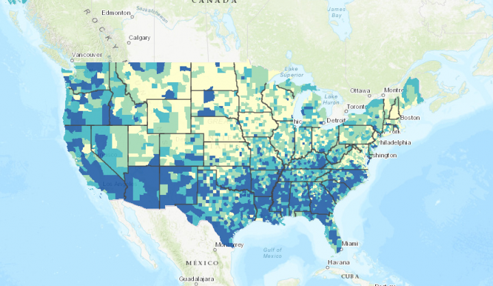
Bridging the Digital Divide for Students without Broadband or Computer Access
In Syracuse, only half of all households have both broadband access and computer devices at home. In some of the poorest areas of the city, only a quarter of households do. With instruction and assignments moving online, this creates a serious problem for many of the city’s students.
Luckily, the city’s data team had already been conducting work around determining which households lacked these resources. Knowing this, the school district reached out for assistance once schools went remote. Again, using data provided by the school district, the team layered student addresses over Census and ACS data on broadband and computer access, poverty and other characteristics. Like the food distribution site maps, they built the maps featured below in just two days.


Using this information, the school district is working to purchase devices to distribute to students in need, and is exploring ways to provide access to WiFi so students can get online. Sam Edelstein, the city’s Chief Data Officer, acknowledged that coordinating these efforts is challenging and the details are being worked out, but the critical thing is that they are working with the right data, and are doing everything they can to address these gaps. He went on to note that “... we knew that people didn't have access to the internet, but we now see really clearly what the impact of that can be... The important thing to remember once this is over is that we have no excuse but to push on the issue and think more critically about how to solve it.”
Adjusting Approaches in Real-Time, but Looking to the Future
Edelstein said that the data team has served as a major support function for these initiatives, and that providing this data in a way that is easily digestible and actionable has been critical in driving policies and actions taken by city leadership. He also added that the team has had to be extremely agile to enable quick turnarounds since conditions in the city are changing almost daily. He found it extremely encouraging that he is seeing data lead the way through extreme uncertainty.
Due to these constant changes in priorities, it can be difficult to think about the future, but that is exactly what the team in Syracuse is trying to do. Edelstein noted that “we as a team are responsible for thinking through how we better prepare for not only the next emergency… but also about how we address the problems of food and broadband access after we return to normal.” He continued on to say, “we have the data and the code is written… we have the basic outline established... and now it is time we do more.”