
How AI Helps Cities Manage Disaster Response Data
As disasters grow more frequent and data from drones, satellites, and sensors floods emergency operations centers, researchers are deploying AI tools to help local leaders cut through the chaos.
If your city has been hit by a major snowstorm, hurricane, or wildfire, you understand how, in a crisis, city leaders quickly become overwhelmed by the onslaught of information coming in: drone footage, 911 calls, social media posts, satellite images, and more. Local leaders must act quickly to determine how best to respond – where to send resources, how to rebuild critical infrastructure, and what messaging to share with residents.
In many ways, today’s disaster response is no longer limited by a lack of data, but rather by the need to process so much data in such little time. Often called the “information overload” or “data avalanche,” it’s becoming more common as new sensors and imaging tools are introduced. Such information bottlenecks can hinder response efforts and delay access to resources, information, and medical care, ultimately impacting health and safety outcomes. Recognizing these challenges, some researchers are exploring how AI can be deployed in disaster response to help leaders make data-driven decisions. For example, could an AI system aid in acute situations and facilitate the work of frontline responders by incorporating cutting-edge technology into emergency response?
Thomas Manzini, a computer science PhD candidate at Texas A&M University, is working to address the very question of how to disseminate information efficiently in disaster response. Manzini works with the National Science Foundation’s AI Institute for Societal Decision Making (NSF AI-SDM) to improve AI systems for use in extreme environments. He draws experience from his joint professional background training and developing AI systems at Microsoft and as a firefighter, EMT, and pilot, which provides him with a unique understanding of how to translate technology into practice.
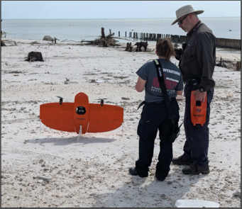
Working in the lab of Dr. Robin Murphy, he is part of a team with a long history of deploying high-tech systems during disasters, including 9/11, Hurricanes Katrina, Irma, Idalia, and Ian, the 2018 Kilauea fires, and the 2021 Champlain Towers collapse. Manzini himself has deployed AI systems to hurricanes Debby and Helene in 2024. Above all, he seeks to help emergency management practitioners mitigate the data avalanche and make the best decisions on the ground.
How does AI work for disaster response?
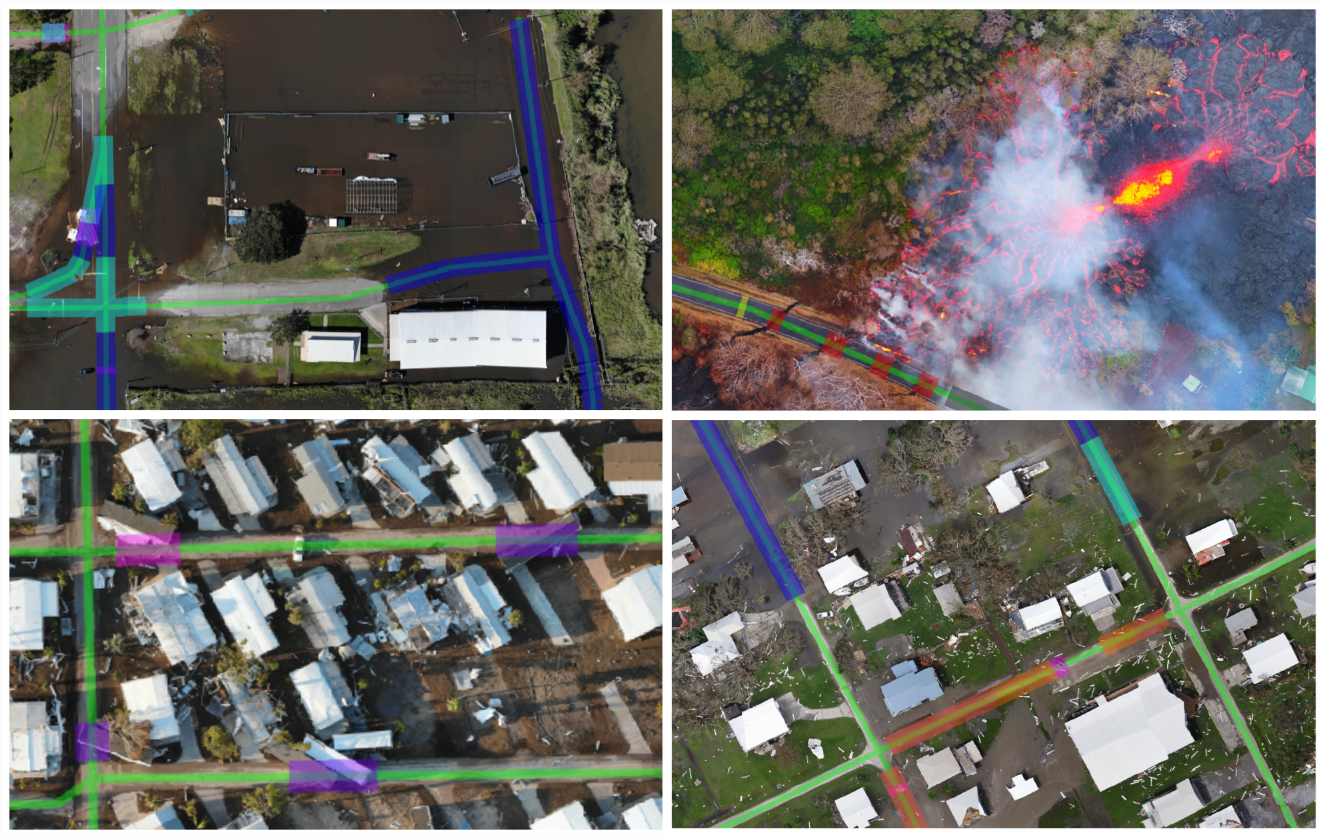
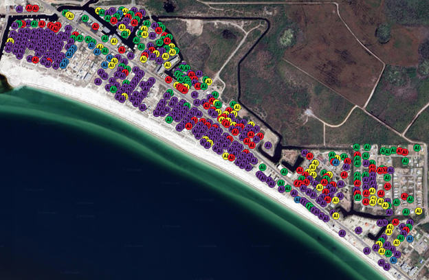
AI models can help deal with the “data avalanche” by synthesizing huge amounts of visual information to help emergency management personnel make key decisions in disaster response. During emergencies, drones fly over disaster areas and capture high resolution pictures of damage as well as the state of critical infrastructure, such as roads, hospitals, and schools. According to Manzini, a drone imaging team might produce 350 gigabytes of imagery, which then needs to be uploaded to decision makers upon teams’ mission returns. This creates the equivalent demand of simultaneously streaming 32 cinema grade high-definition movies from the middle of a disaster scene, in a few hours. While this information is all critical to emergency management and decision-making, the sheer volume is overwhelming. AI models can take this imagery and evaluate the damage, assigning it a score, and creating actionable summaries for emergency managers.
“Our work is really focusing on managing that information flow so that we can get the right information to the right people at the right time,” Manzini said.
In addition to refining AI models, Manzini underscored the need to develop high-quality datasets for researchers to build further models. For instance, through his work at Texas A&M he and his collaborators have compiled the world’s largest known, publicly available, dataset of aerial disaster imagery, called CRASAR-U-DROIDs (Center for Robot Assisted Search and Rescue Uncrewed Disaster Response Overheat Inspection Dataset) spanning 10 disasters and 21,000 buildings. This data was then used to train CLARKE, an AI system capable of automatically detecting damage to buildings and roads in drone imagery, which was deployed operationally in Florida and Pennsylvania during Hurricanes Debby and Helene.
“There's been a lot of effort in curating, bringing that data to a point where machine learning scientists can sit with it and train and evaluate their own models and hopefully make improvements on the systems that we built,” Manzini said.
Many people assume that AI must be highly accurate to provide meaningful benefits to emergency management personnel. In fact, the biggest takeaway from Manzini’s work has been that today’s AI models are already good enough to be used in disaster response.
“When we started having conversations about deploying these systems, we were really concerned about errors and potential downstream negative effects from those errors,” he said. “The thing that has surprised us the most is that practitioners really tolerate errors well.”
While many researchers typically assume that high accuracy is necessary for frontline practitioners, Manzini found that a lower accuracy level is acceptable, as long as the information is delivered rapidly. Through structured tabletop exercises with emergency management practitioners in Florida, Manzini found that respondents were open to working with 50% accuracy if the information was available within a day. This suggests that in the early stages of disaster response it is better for information to be quick and dirty versus perfect but late. It also indicates that many AI systems are already sufficient to be used in disaster response alongside human decision-making by frontline personnel.
Challenges and best practices for AI adoption
Given that adoption of AI models is often driven by state and local governments, Manzini said bottom-up adoption is key, starting with conversations to ensure AI systems meet the needs of emergency managers. Likewise, fitting AI models into existing workflows may be challenging and is best handled through conversations with the personnel already engaged in that work.
Disasters often destroy wireless infrastructure, so it’s essential to ensure AI systems are readily accessible and aren’t located solely in the cloud. For instance, state and local government should consider investing in portable hardware and technology that can run AI systems offline. While satellite-based connectivity (such as Starlink) can be helpful, Manzini said his team quickly overwhelmed Starlink capacity with data during Hurricane Ian. Budgetary constraints are an important consideration as well. While some large tech companies have begun offering their AI systems for use in disaster and humanitarian crises for free, Manzini said state and local governments should consider the cost of either paying tech companies for access to AI models online, or for paying for edge computing hardware to host academic and open-source models on their own.
As with any new technology, it’s also crucial to consider how to avoid reinforcing systemic inequities. Disasters tend to disproportionately affect lower-income areas, but Manzini said these areas were already pretty well‑represented in the training data. For instance, when examining data from AI deployment in Hurricanes Helene and Debby, his team found more issues related to sensor quality and imagery resolution than to socioeconomic factors. Manzini also stressed the importance of human oversight for any signs of systemic biases.
“It's absolutely a balancing act in practice because we don't know how the next disaster is going to disproportionately affect the community or population,” he said. Ultimately, the best practice is to ensure that AI output is combined with local knowledge and metrics to prioritize the most vulnerable.
Overall, Manzini expressed optimism for the potential of these systems to better serve emergency managers operating in time-sensitive, stressful conditions on the frontlines of disaster response. “On the academic side, we've done a fairly deep investigation of the potential risks and are working on communicating that to the practitioners,” he said. “But again, surprisingly, that hasn't really been their focus when it's come to questions of adoption.”
The future of AI for disaster response
While a human surveying building damage can do a good job fusing together visual information from different sources – say, a picture from a satellite and a picture taken by a drone – AI systems struggle to make sense of data in different formats or from different sources. Manzini said that building machine learning systems that can deliver high-quality insights regardless of source or resolution is a key focus for future academic research. This is especially important in disaster response, as there may be uncertainty about what data sources will be available on any given day. For instance, drones or aircraft may not be able to fly in bad weather, but there may be data available from vehicles on the ground, or even from residents’ social media posts.
And what about the potential of generative AI (Gen AI) to support disaster response? The most promising use cases, according to Manzini, are before and between disasters. For instance, Gen AI can help develop training materials for emergency managers or to scan documentation to identify best practices for different types of disaster response. Looking to the future, Manzini said he hopes that Gen AI will be able to synthesize information from multiple data sources into streamlined dashboards for incident command and city leadership:
“I'm really excited about the potential to fuse additional sources of data into these models [to create] a global picture of all of that information in a way that's not overwhelming to people. I think it is going to be a very positive thing to happen in the coming years.”
Local leaders and regional emergency personnel should know that AI models are advanced enough to deploy in disasters and can help synthesize vast quantities of information to inform decision-making in an efficient, data-driven manner. Mayors and local leaders shouldn’t wait for the “perfect” AI system to come along but rather should start small with bottom-up adoption of existing systems for frontline emergency managers. As the saying goes, don’t let the perfect be the enemy of the good.
“Emergency managers are a population that are very willing to accept new technology, but only if it actually makes their job better,” Manzini said. “Now we're getting to the point where these AI systems are able to actually make a difference in practice,” he said. “And we're excited to get those new tools into the hands of the practitioners.”
About the Author
April Hopcroft

April Hopcroft is a Masters of Public Health graduate student at the Harvard T.H. Chan School of Public Health. Previously, she worked as a staff writer and is currently a summer employee with the New Hampshire Department of Health and Human Services. She earned a BA in Neuroscience and Spanish from Smith College in 2021.